Winter weather is arriving earlier than usual in several parts of the United States. The National Weather Service (NWS) has issued warnings for Alaska, the Northeast, and Colorado. Interior Alaska is expected to see heavy snowfall, with forecasts predicting up to 9 inches between Thursday afternoon and Friday evening.
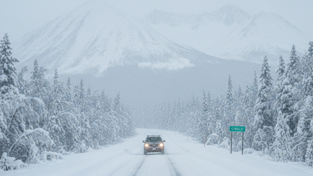
The snowstorm is likely to create hazardous driving conditions, especially along major routes like the Steese and Elliott Highways. Motorists are advised to reduce speed, maintain safe distances, and check road conditions regularly. Residents should also exercise caution on sidewalks, driveways, and stairs, as icy conditions can develop quickly.
Meanwhile, the Northeast is preparing for frost and freezing temperatures, which could damage outdoor plants, crops, and gardens. Homeowners and gardeners are encouraged to cover sensitive plants, bring potted plants indoors, and take preventive steps to protect vegetation from early-season frost.
These early winter conditions highlight the importance of preparedness. Staying informed through NWS alerts, planning travel carefully, and taking safety precautions can help reduce risks. Whether navigating snowy roads in Alaska or protecting gardens in the Northeast, residents are urged to remain alert as winter weather begins to impact multiple regions.
Heavy Snow Expected in Alaska
The NWS has issued a winter weather advisory for interior Alaska, including key regions such as:
- White Mountains
- High terrain south of the Yukon River
- Chatanika River Valley
- Steese and Elliott Highways
According to the NWS, snow accumulation is expected to range between 4 and 9 inches, with higher elevations receiving the most snow. The storm is expected to start with light snowfall Wednesday night, intensifying Thursday night and lasting through Friday evening.
Key Travel Warnings
The snowstorm is likely to create hazardous travel conditions across the region. The NWS has advised:
- Drivers to reduce speed and maintain a safe following distance.
- Motorists to check current road conditions via 511 before traveling.
- Caution when walking outdoors, as stairs, sidewalks, and driveways may become slippery.
“Plan on hazardous road conditions. The storm could impact Thursday evening and Friday morning commutes,” the NWS advisory warned.
Residents are also advised to prepare for possible delays and ensure vehicles are equipped with winter tires, emergency kits, and blankets.
Early Snow in Fairbanks
Fairbanks, Alaska, has already seen over an inch of snow last weekend. NWS Fairbanks reported 1.2 inches, which is about two weeks ahead of the typical first snowfall of the season, usually occurring around October 9. While this early snow may not persist for long, it signals that winter is approaching sooner than usual.
Moderate to heavy snowfall is expected in the White Mountains, with the Steese and Eagle Summits and Upper Chatanika Valley receiving the highest amounts. Lower elevations may experience mixed precipitation, including sleet or light rain.
Frost Risk in the Northeast
While Alaska prepares for heavy snow, the Northeast faces a different type of winter weather hazard: frost and freezing temperatures.
Areas Most Affected
- New England states
- Upstate New York
- Northern Mid-Atlantic regions
The NWS warns that temperatures dipping below freezing can damage or kill sensitive plants, vegetables, and flowers. Homeowners and gardeners are advised to:
- Cover outdoor plants with blankets or frost cloths.
- Move potted plants indoors during the night.
- Avoid watering plants late in the evening, as frozen water can harm roots.
Even short periods of frost can significantly impact local gardens and agriculture, making early preparation crucial.
What Causes These Early Winter Conditions?
Several factors contribute to the early onset of winter weather in different regions:
- Arctic Cold Fronts: Cold air masses moving south from the Arctic bring snow and frost to interior Alaska and the northern U.S.
- Moisture Levels: Increased humidity in certain regions leads to snowfall when temperatures drop below freezing.
- Elevation Differences: Higher elevations in Alaska, such as the White Mountains and Steese Highway, experience more snow accumulation due to colder temperatures at altitude.
These conditions can create sudden and unexpected hazards, making it essential for residents and travelers to stay informed.
Safety Precautions for Residents
To stay safe during early winter weather, the NWS recommends:
- Driving Safety: Slow down, increase the distance between vehicles, and avoid sudden braking or sharp turns on icy roads.
- Pedestrian Safety: Be careful on sidewalks, stairs, and driveways, as ice may form quickly.
- Weather Updates: Check NWS updates regularly via local news, radio, or official websites.
- Emergency Preparedness: Keep an emergency kit in your vehicle, including blankets, food, water, and a flashlight.
By taking these precautions, residents can reduce the risk of accidents and injuries during winter storms.
Impact on Transportation
Heavy snow in Alaska is expected to affect key highways and commuting routes, including the Steese and Elliott Highways. Drivers should anticipate:
- Slower traffic and possible road closures
- Reduced visibility during snow showers
- Icy and slippery road surfaces
Public transportation and air travel may also experience delays due to snow accumulation and icy conditions. Travelers are advised to confirm schedules before departure.
Preparing for Frost in the Northeast
Gardeners and homeowners in the Northeast should take preventive measures to protect plants:
- Cover crops and sensitive plants: Use frost blankets or sheets to shield plants from freezing temperatures.
- Bring potted plants indoors: Move any portable plants inside overnight.
- Check irrigation systems: Avoid leaving water on the ground overnight, as frozen water can damage roots.
These simple steps can help minimize damage and preserve plant life during unexpected frost events.
Monitoring Winter Weather
The NWS continues to monitor weather patterns closely and will issue updates as conditions change. Residents are encouraged to:
- Follow local news for road and weather advisories.
- Sign up for NWS alerts via email or text messages.
- Stay prepared for sudden changes in temperature or precipitation.
Staying informed is the best way to remain safe and minimize disruption during early winter weather.
Winter Weather Q&A: Alaska Snowstorm & Northeast Frost
Q1: Which regions are affected by the early winter weather?
A1: The National Weather Service (NWS) has issued alerts for interior Alaska, the Northeast, and parts of Colorado. Alaska is expecting heavy snowfall, while the Northeast faces frost and freezing temperatures.
Q2: How much snow is expected in Alaska?
A2: Interior Alaska could see up to 9 inches of snow between Thursday afternoon and Friday evening, with higher elevations like the White Mountains and Steese Highway receiving the most accumulation.
Q3: What precautions should drivers take in Alaska?
A3: Motorists should reduce speed, maintain safe distances, check road conditions via 511, and prepare for icy roads. Extra caution is advised during morning and evening commutes.
Q4: How will the frost affect the Northeast?
A4: Frost and freezing temperatures could damage outdoor plants, gardens, and crops. Homeowners are advised to cover plants, bring potted plants indoors, and protect sensitive vegetation.
Q5: How can residents stay informed about changing weather conditions?
A5: Stay updated through official NWS alerts, local news, radio, and online weather channels. Following timely updates can help prevent accidents and minimize damage to property or vegetation.
….
Read more News Articles