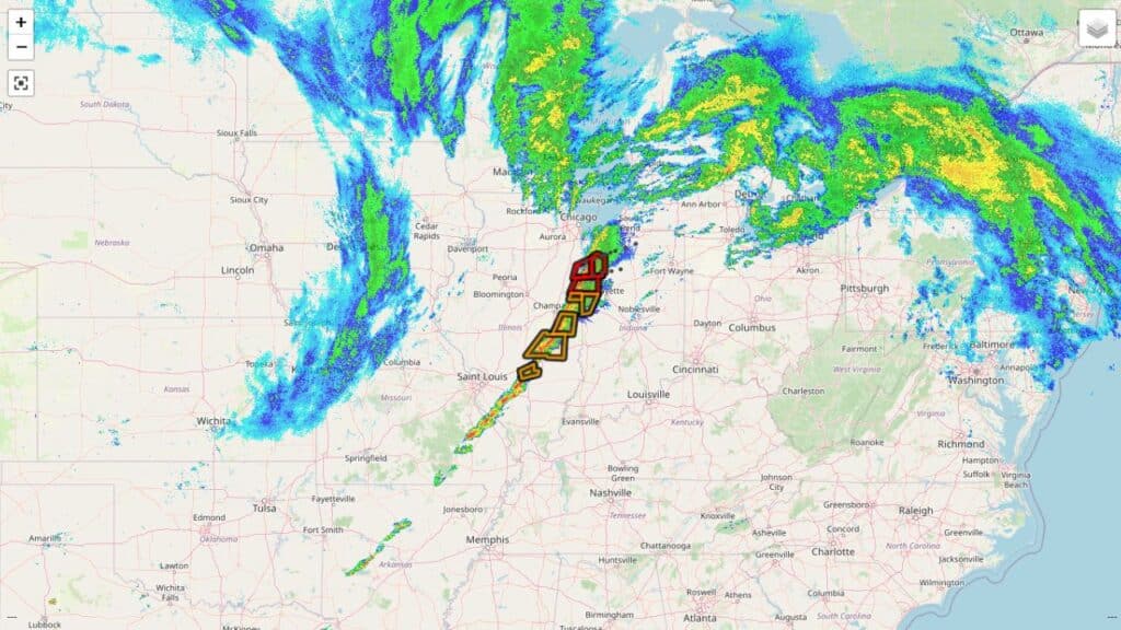
A large portion of the Midwest remained on alert Sunday evening after the National Weather Service (NWS) issued a Tornado Watch for parts of Indiana, Illinois, Kentucky, and Missouri, warning residents of the potential for dangerous storms capable of producing tornadoes, damaging winds, and large hail.
The watch was issued Sunday afternoon as meteorologists tracked a strong line of storms pushing eastward across the region. Forecasters said atmospheric conditions had become increasingly favorable for severe weather, prompting officials to issue the alert to give residents time to prepare. Depending on location, the Tornado Watch is set to remain in effect until 8:00 or 9:00 p.m.
Indiana Among the Most Impacted States
In Indiana, the Tornado Watch includes a wide stretch of counties across the western, central, and southern portions of the state. Areas under the watch include Marion, Hamilton, Johnson, Tippecanoe, Monroe, Hendricks, Boone, Morgan, Greene, Cass, Clinton, Carroll, White, Putnam, Parke, Owen, and Lawrence, among others.
Forecasters say the storms moving through Indiana could bring strong wind gusts reaching up to 75 miles per hour, along with hail large enough to cause damage to vehicles and property. While tornadoes are not guaranteed, the NWS emphasized that the potential exists, particularly as storms intensify during the late afternoon and evening hours.
Weather experts noted that the storm system is extensive and could affect more than five million people, making it one of the more significant weather events of the weekend.
Illinois, Kentucky, and Missouri Also Under Alert
The Tornado Watch also extends into southern Illinois, where counties such as Franklin, Jefferson, Williamson, Union, Saline, Perry, White, Washington, Wayne, and Randolph are included. Residents in these areas were urged to stay weather-aware and be prepared for rapidly changing conditions.
In western Kentucky, most counties remain under the watch, including Hopkins, Caldwell, Lyon, Ballard, Daviess, Henderson, McCracken, Livingston, Webster, and Union. However, officials noted that not every county in the region is included, and residents were advised to check local alerts carefully.
Parts of southeastern Missouri, including Cape Girardeau, Bollinger, Perry, and Scott counties, are also impacted as the storm line continues to move eastward.
Understanding What a Tornado Watch Means
Officials stressed the importance of understanding the difference between a Tornado Watch and a Tornado Warning. A watch means that conditions are favorable for tornadoes to form, but none have been confirmed yet. A warning, on the other hand, indicates that a tornado has been detected or spotted and immediate action is required.
While under a watch, residents are encouraged to review safety plans, identify safe shelter locations, and remain alert to weather updates. Forecasters caution that storms can strengthen quickly, leaving little time to react once warnings are issued.
Additional Threats: Wind and Hail
Beyond the tornado risk, the storm system poses a significant damaging wind threat. In some areas, straight-line winds could be strong enough to knock down trees, damage power lines, and cause scattered power outages.
The National Weather Service has also issued a Wind Advisory for much of western Kentucky, with gusts expected to reach around 40 miles per hour Sunday evening into early Monday morning.
Hail is another concern, with some storms capable of producing hail as large as a quarter. While brief, hail can still damage roofs, vehicles, and crops, particularly during intense storm cells.
Sharp Temperature Drop Expected
One of the most noticeable changes following the storms will be a dramatic drop in temperatures. Ahead of the storm system, many areas experienced mild conditions with temperatures near 60 degrees. However, once the storms move through, much colder air will rush in behind the front.
Forecasts indicate that temperatures will fall quickly into the 20s, with overnight lows dipping into the upper teens by Monday and Tuesday mornings. When combined with strong winds, wind chills could drop into the single digits, creating dangerously cold conditions.
Meteorologists say residents should prepare for winter-like weather returning abruptly after the storms pass.
Timing and Storm Movement
The line of storms is expected to continue moving from west to east through the evening. While some areas may see storms weaken after sunset, forecasters warn that severe weather can still occur at night, when visibility is reduced and people may be less aware of changing conditions.
The National Weather Service expects the system to gradually weaken as it moves east of Indianapolis later in the evening, though lingering strong winds and colder air will remain.
Safety Tips for Residents
Emergency officials urge people in the affected areas to take the Tornado Watch seriously. Recommended safety steps include:
- Keeping a weather radio or smartphone alerts turned on
- Knowing the safest place to shelter, such as a basement or interior room
- Securing loose outdoor items that could become airborne
- Avoiding travel during severe storms if possible
Drivers are also advised to use caution, as strong winds and heavy rain can reduce visibility and make driving hazardous.
Staying Informed
Residents are encouraged to follow updates from the National Weather Service and local meteorologists throughout the evening. Conditions may change quickly, and additional advisories or warnings could be issued if storms intensify.
While not every location under the Tornado Watch will experience severe weather, officials emphasize that preparedness is key. Staying alert and informed can make a critical difference if dangerous conditions develop.
As the storm system moves out later tonight, calmer but much colder weather is expected to settle across the region to start the new week.
Read other Article